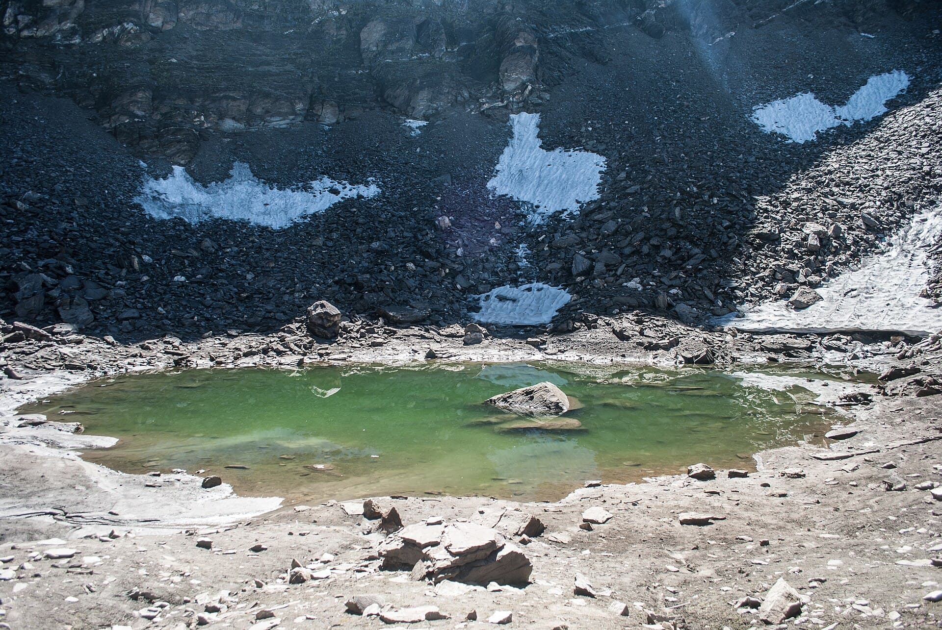
Roopkund
The lake that keeps its own history at the bottom.
Photo: Schwiki / Wikimedia Commons (CC BY-SA 4.0)
Challenging
Difficulty
53 km
Distance
7D / 6N
Duration
4,800 m / 15,748 ft
Peak Altitude
Summer, Post-Monsoon
Best Season
Why This Trek
Roopkund
Roopkund isn't just a striking name and a mystery lake - it's one of the more demanding treks in this part of the Himalaya, in a zone where access rules have changed within the last few months. We'd rather list it honestly, flag exactly what's still unsettled, and run it ourselves before we ask anyone to book it.
Before You Book
- Forest access may require a valid permit.
- Authorised guide support may be mandatory.
- Departure depends on current route availability.
- Weather and wildlife conditions may affect access.
- Route and timings can change for safety reasons.
- Camping is only offered where currently permitted.
- Government ID may be required for permit registration.
- Final confirmation is issued only after operational verification.
The Trail
From Lohajung, the trail drops into forest toward Didna village before climbing steadily into the open expanse of Ali Bugyal and Bedni Bugyal - vast alpine meadows that give the trek its scale. Beyond Bedni, the route climbs past Patar Nachauni and Kalu Vinayak to the high camp at Bhagwabasa, from where a long summit day crosses moraine and snow to reach Roopkund itself, sometimes continuing to the Junargali ridge above it. The return retraces the route back through the bugyals to Wan and Lohajung. This is sustained high-altitude terrain with real exposure to weather and snow, not a graded path throughout.
- Ali and Bedni Bugyal, two of the largest high-altitude meadows in the Garhwal Himalaya
- Roopkund itself, a small lake ringed by centuries-old human skeletal remains
- Junargali ridge, with views toward Trisul and the wider Nanda Devi massif
- A genuinely remote, multi-day high-altitude route - not a weekend add-on
Itinerary
- 1
Lohajung to Didna village
An initial descent and river crossing before a climb into the forested village of Didna, the first camp on the route.
6 km · +300 m
- 2
Didna to Ali Bugyal
A steep climb through oak and rhododendron forest that opens abruptly onto the vast Ali Bugyal meadow.
8 km · +900 m
- 3
Ali Bugyal to Patar Nachauni via Bedni Bugyal
A high traverse across two of the region's largest bugyals, with Trisul and the Nanda Ghunti massif visible for most of the day.
7 km · +400 m
- 4
Patar Nachauni to Bhagwabasa
Climb past the Kalu Vinayak shrine into thinning, rockier terrain to the high camp at Bhagwabasa, the base for the summit day.
6 km · +700 m
- 5
Bhagwabasa to Roopkund and back
A long, high-altitude push across moraine and snow to Roopkund lake, with a return descent to Bhagwabasa the same day.
8 km · +750 m
- 6
Bhagwabasa to Wan
A long descent day, retracing the bugyal traverse back down toward Wan village.
15 km
- 7
Wan to Lohajung
A final, shorter descent back to Lohajung, closing the loop.
3 km
Who Is This Trek For?
Fitness level required: high. Group size runs 6–12 people. Age range: 16–50 years.
All participants must share a valid medical fitness certificate before booking - this trek crosses 4,800m and is not suitable for anyone with cardiac, respiratory or high-altitude-related conditions.
Inclusions & Exclusions
- Forest permit and group registration coordination, and authorised trek guide
- Trek leader and on-trail first-aid support
- All meals and camping equipment on the trail
- Travel to and from Lohajung
- Personal high-altitude trekking gear (shoes, down jacket, poles, etc.)
- Any stay before or after the trek
- Medical certificate fee, where applicable
What to Carry
- Insulated, waterproof trekking shoes with ankle support
- Down jacket and full thermal layering for sub-zero high-altitude camps
- Gaiters, trekking poles and micro-spikes for snow and moraine
- Headlamp, sunglasses and high-SPF sunscreen for snow glare
Safety
- Trek leader carries a first-aid kit and satellite communication where network is unavailable
- This trek crosses 4,800m - acclimatisation days are built into the itinerary and are not optional
- Snow, wind and whiteout conditions near Bhagwabasa and Roopkund can force a same-day turnaround
- Group pace is set by the slowest member, not the fastest
- Human skeletal remains at Roopkund are a protected archaeological feature - they are not to be touched, moved or removed
Permits
Roopkund sits in an eco-sensitive high-altitude zone bordering the Nanda Devi Biosphere Reserve. Forest entry permits and group registration are required through the Lohajung forest outposts, and the route has recently seen real regulatory change: an eight-year Forest Department ban on overnight camping on the Ali and Bedni Bugyal meadows - the classic route's traditional campsites - was only set aside by the Supreme Court in July 2026. The exact post-ruling booking process, documentation and any new group-size or waste-management conditions are still being confirmed locally as Forest Department procedure catches up to the court order. We're treating this as unverified until we've confirmed the current process directly with the Forest Department and run the route ourselves.
Cancellation Policy
A ₹1,000 Booking Advance secures your booking request. Final confirmation is issued only after operational and permit verification. The advance is non-refundable and non-transferable, as it blocks your spot in the group.
If we cancel a trek due to weather, safety, or forest department restrictions, you get a full refund or a free reschedule.
Notes
Permit and registration process for Roopkund is in active flux following the July 2026 Supreme Court ruling on bugyal camping - all figures here are pre-verification and must be reconfirmed with the Forest Department before booking opens.
Sustainability
The bugyal meadows on this route were under an 8-year camping ban specifically because they're slow to recover from overuse - even with that ban lifted, we'll follow whatever waste and site rules the Forest Department sets, not the loosest interpretation of them.